Highlights 1,865 g/t Ag and 0.96% Pb over 2.0 m and
1,665 g/t Ag, 0.43% Pb and 1.42% Cu over 2.0 m
VANCOUVER, British Columbia – September 29, 2020 – New Pacific Metals Corp. (“New Pacific” or the “Company”) is pleased to provide an update on its exploration activities at its Silverstrike Project, Bolivia. New Pacific acquired a 98% interest in the Project in December 2019 (please refer to news release dated December 4, 2019). Reconnaissance and detailed mapping and sampling programs have been completed on the northern portion of the Project. The results to date indicate good to excellent exploration potential for hosting narrow high-grade and near-surface broad-zones of silver mineralization.
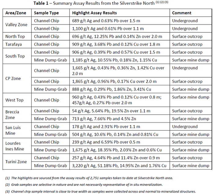
Summary highlights of the results received to date are tabulated below in Table 1:
Detailed Mapping and Sampling Program
Silverstrike North is centred on the historic Berenguela Mining District and is characterized by abundant historic mine adits, declines, shafts and spoil heaps scattered intermittently over an approximately 3.5 by 2.2 km area. It includes the Valley Zone, North Top, Tarafaya Mine, South Top, West Top, and CP Zone in addition to the former San Luis Mine, Lourdes Ines Mine and the Turini Mine which are discussed below (Figure 1).
In March 2020, the Company initiated an integrated exploration program consisting of 1:5000 scale reconnaissance and 1:500 scale detailed geological, structural and alteration mapping and geochemical sampling programs. The program aimed to geologically define and sample the extents of the hydrothermal system(s), including extensive Spanish Colonial-era historic workings to develop drill targets.
The exploration team identified and sampled numerous mining adits, declines, shafts and surface open pits. Historic mining operations were developed along steeply dipping fracture zones which ranged from 0.5-2 meters wide developed in altered / bleached Tertiary aged sandstones. In addition, several new mineralized zones were identified as part of the field work.
A total of 2,751 samples were collected including 2,607 channel chip samples and 144 mine dump grab samples. Majority of the samples were taken from surface outcrops of alteration and mineralization. All 2,751 assay results have been received of which, 56 samples have silver grades >300 g/t (average 696 g/t Ag), 163 samples with >100 g/t (average 347 g/t Ag), and 236 samples >50 g/t (average 262 g/t Ag).
Representative channel chip samples were collected perpendicular to outcropping altered fractures, however, in many areas historic mining activities and resultant waste dumps obscure the facture zones. Underground channel chip sampling across mineralized zones typically returned grades ranging from a few hundred to more than one thousand ppm Ag and associated base metals (Pb, Zn and Cu – see tables for details).
DETAIL – see Figure 1 for locations
Valley Zone forms the core of the Berenguela Mining District and is defined by abundant historic mine workings over an area of approximately 1,800 m long in an E-W direction and 300 m wide in a N-S direction (Figure 1). Six adits were mapped and sampled and 20 channel chip samples of mineralized veins were collected returning average grades of 306 g/t Ag, 1.06% Pb over 1.08 m with the best interval of 1.1 m @ 1,100g/t Ag and 0.61% Pb from the San Jose Mine Adit #-4.
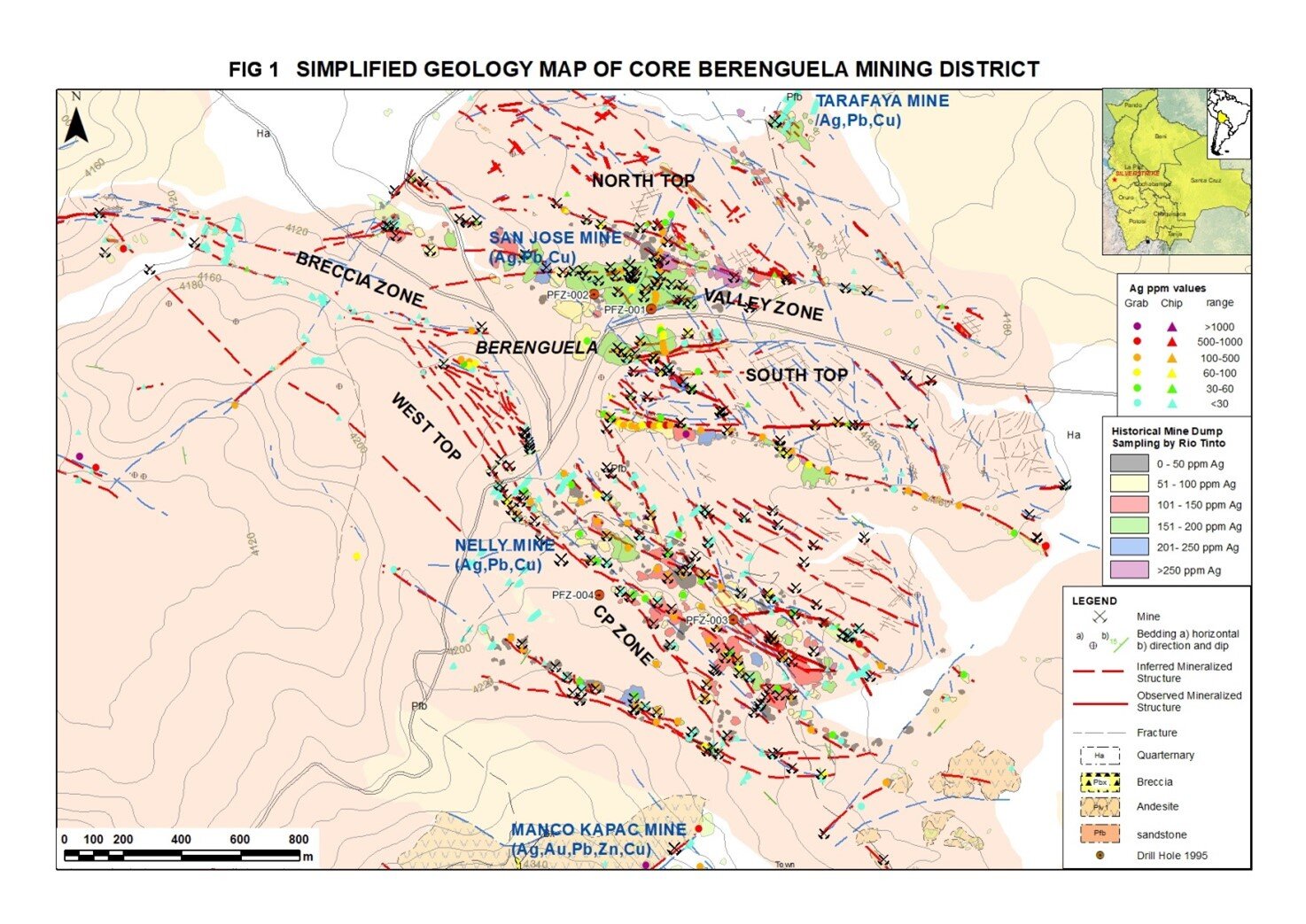
North Top Zone located immediately north of the Valley Zone is comprised of sub-horizontal sandstones cut by NWW striking mineralized fractures over an area 1,600 m long in E-W direction and 300 m wide in a N-S direction (Figure 1). Channel chip sampling returned grades up to 696 g/t Ag and 12.25% Pb over 2 m.
Tarafaya Mine Zone is located approximately one kilometre to the north of Berenguela village (Figure 1). The channel chip sampling across mineralized fractures returned grades of up to 909 g/t Ag, and 3.68% Pb over 1.8 m, and 455 g/t Ag and 1.31% Pb over 1.4 m.
West Top Zone forms a topographic high of horizontal sandstones adjacent to the Valley Zone (Figure 1). Mine dump grab sampling returned grades up to 265 g/t Ag and 0.53% Pb, and channel chip sampling returned up to 960 g/t Ag and 0.43% Pb over 0.8 m, and 457 g/t Ag and 0.27% Pb over 2 m.
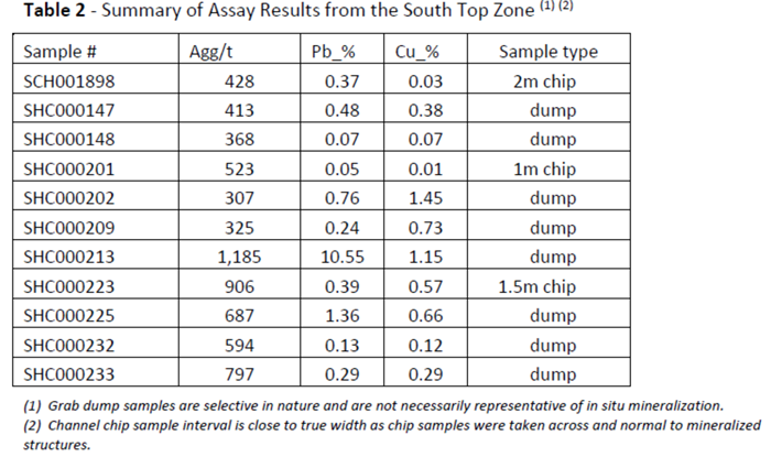
South Top Zone is a flat area of sub-horizontal sandstones cut by numerous NWW striking mineralized fractures defining a mineralized corridor 1,600 m long in E-W direction and 300 m wide in N-S direction (Figure 1).
The team collected 448 samples of which grab sample results returned values up to 1,185 g/t Ag, 10.55% Pb and 1.15% Cu and the highest channel chip channel sample results of 906 g/t Ag, 0.39% Pb and 0.57% Cu over 1.5 m. Table 2 summarizes assay results with silver grades higher than 300 g/t.
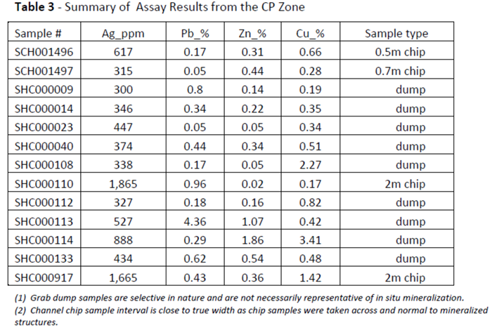
CP Zone, site of the former Nelly Mine, covers an area of 2,500 m long in E-W direction and 800 m wide in N-S direction and is defined by extensive areas of talus material and widespread mining dumps (Figure 1). This structural fairway extends into the West Top Zone.
Systematic dump grab sampling (a total of 82 samples) returned average grades of 129 g/t Ag, 0.54 Pb%, 0.48% Zn and 0.34% Cu with the highest value of 888 g/t Ag, 0.29% Pb, 1.86% Zn and 3.41% Cu.
Underground channel chip sampling in five adits returned values up to 1,665 g/t Ag, 0.43% Pb, 0.36% Zn and 1.42% Cu over 2 m. Surface channel chip sampling across mineralized fractures returned values up to 1,865 g/t Ag, 0.96% Pb and 0.17% Cu over 2 m. Table 3 summarizes assay results with silver grades higher than 300 g/t.
Breccia Zone is located to the west of Berenguela village (Figure 1). It is a sporadically outcropping, NNW trending, tectonic-hydrothermal breccia zone of about 2 km long and up to 50 m wide. Historic mine workings (adits, surface cuts and mine dumps) occur along its length. Two mine dump grab samples returned values of 713 g/t Ag, 7.66% Pb and 4.5% Zn and 223 g/t Ag, 0.41% Pb, 0.59% Zn and 1.27% Cu, respectively. Channel chip samples from surface reported grades up to 54 g/t Ag, 5.64% Pb and 19.5% Zn over 1.1 m.
San Luis Mine Zone forms the northernmost extent of the Silverstrike North area and is comprised of mineralized fracture zones developed in sub-horizontal altered Tertiary sandstones. These fracture swarms constitute a broad corridor approximately 1 km long in an east-west direction and up to 70 m wide in north-south direction. Mine dump grab sampling of seven samples returned average grades of 157 g/t Ag, 6.71% Pb and 9.52% Zn with the highest returning 504 g/t Ag, 10.6% Pb and 0.81% Cu. Channel chip sampling across an accessible underground drift returned grades up to 178 g/t Ag and 2.91% Pb over 1.1 m.
Lordes Ines Mine Zone is located 2,300 m to the southwest of the Berenguela village. The zone is dominated by two sets of cross cutting mineralized fractures developed in sub-horizontal Tertiary sandstones. Interaction between the crosscutting fractures forms a stockwork of veinlets and crackle breccia mappable as a broad mineralized structural corridor of circa 2 km long and 100 m wide. Many of the former mine workings are inaccessible however mine dump grab sampling returned average grades of 635 g/t Ag, 18.43% Pb, 0.95% Zn and 0.79% Cu (n=5) with the highest values of up to 1,675 g/t Ag, 18.35% Pb, 2.03% Zn and 0.6% Cu.
Seventy-five channel chip samples of surface fractures returned grades up to 239 g/t Ag and 6.59% Pb over 0.5 m wide, and a channel chip sample from a breccia zone returned grades of up to 94 g/t Ag, 2.62% Pb and 3.06% Zn over 1.5 m.
Turini Mine Zone is located 1.8 km to the west of Berenguela village. Mine dumps are distributed along a corridor of 1,100 m long and up to 50 m wide. Five mine dump grab samples returned average grades of 886 g/t Ag, 18.88% Pb, 5.33% Zn, 0.72% Cu with the highest values up to 3,220 g/t Ag, 51.18% Pb, 14.95% Zn and 1.76% Cu.
Forty channel chip samples were collected with the highest returning up to 257 g/t Ag, 4.64% Pb and 11.4% Zn over 0.9 m wide. No underground workings were accessible.
FUTURE WORK
New Pacific’s exploration team is currently completing mapping and sampling of the Silverstrike Central and South areas summary results of which will be released upon receipt. Following integration of the geochemical sample results and geological data, the Company will generate drill targets for testing upon receipt of required drill permits which is tentatively anticipated in Q4 2020.
Quality Assurance and Quality Control
The grab and chip samples with results released in the news release were shipped in securely sealed bags by New Pacific staff in the Company’s vehicles directly from field to ALS Global in Oruro, Bolivia for preparation, and ALS Global in Lima, Peru for geochemical analysis. All samples are first analyzed by a multi-element ICP package (ALS code ME-MS41) with ore grade over limits for silver, lead and zinc further analyzed using ALS code OG46. Further silver over limits are analyzed by gravimetric analysis (ALS code of GRA21).
The assay results of the grab and chip samples are used for reconnaissance purpose, hence no certified reference materials and blank materials were inserted to the normal sample sequence in the field. However, internal QAQC results of ALS lab did not show any significant bias of analysis or contamination during sample preparation.
Technical information contained in this news release has been reviewed and approved by Alex Zhang, P. Geo., Vice President of Exploration, who is a Qualified Person for the purposes of NI 43-101.
ABOUT NEW PACIFIC
New Pacific is a Canadian exploration and development company which owns the Silver Sand Project, in the Potosi Department of Bolivia and the Tagish Lake Gold Project in Yukon, Canada.
For further information, please contact:
New Pacific Metals Corp.
Gordon Neal
President
Phone: (604) 633-1368
Fax: (604) 669-9387
info@newpacificmetals.com
www.newpacificmetals.com
CAUTIONARY NOTE REGARDING FORWARD-LOOKING INFORMATION
Certain of the statements and information in this news release constitute “forward-looking information” within the meaning of applicable Canadian provincial securities laws. Any statements or information that express or involve discussions with respect to predictions, expectations, beliefs, plans, projections, objectives, assumptions or future events or performance (often, but not always, using words or phrases such as “expects”, “is expected”, “anticipates”, “believes”, “plans”, “projects”, “estimates”, “assumes”, “intends”, “strategies”, “targets”, “goals”, “forecasts”, “objectives”, “budgets”, “schedules”, “potential” or variations thereof or stating that certain actions, events or results “may”, “could”, “would”, “might” or “will” be taken, occur or be achieved, or the negative of any of these terms and similar expressions) are not statements of historical fact and may be forward-looking statements or information.
The Company cautions the reader that forward-looking statements or information are subject to a variety of known and unknown risks, uncertainties and other factors that could cause actual events or results to differ from those reflected in the forward-looking statements or information, including, without limitation, risks relating to: fluctuating equity prices, bond prices, commodity prices; calculation of resources, reserves and mineralization, foreign exchange risks, interest rate risk, foreign investment risk; loss of key personnel; conflicts of interest; dependence on management and others.
This list is not exhaustive of the factors that may affect any of the Company’s forward-looking statements or information. Forward-looking statements or information are statements about the future and are inherently uncertain, and actual achievements of the Company or other future events or conditions may differ materially from those reflected in the forward-looking statements or information due to a variety of risks, uncertainties and other factors, including, without limitation, those referred to in the Company’s Annual Information Form for the year ended June 30, 2020 under the heading “Risk Factors”. Although the Company has attempted to identify important factors that could cause actual results to differ materially, there may be other factors that cause results not to be as anticipated, estimated, described or intended. Accordingly, readers should not place undue reliance on forward-looking statements or information.
The Company’s forward-looking statements or information are based on the assumptions, beliefs, expectations and opinions of management as of the date of this news release, and other than as required by applicable securities laws, the Company does not assume any obligation to update forward-looking statements or information if circumstances or management’s assumptions, beliefs, expectations or opinions should change, or changes in any other events affecting such statements or information. For the reasons set forth above, investors should not place undue reliance on forward-looking statements or information.
Cautionary Note to US Investors
This news release has been prepared in accordance with the requirements of Canadian National Instrument 43-101 – Standards of Disclosure for Mineral Projects (”NI 43-101”) and the Canadian Institute of Mining, Metallurgy and Petroleum Definition Standards, which differ from the requirements of U.S. securities laws. NI 43-101 is a rule developed by the Canadian Securities Administrators that establishes standards for all public disclosure an issuer makes of scientific and technical information concerning mineral projects.