Silver Sand Project
History, Geology, Mineralization
Mineral Concessions & Ownership
Exploration Potential at Silver Sand
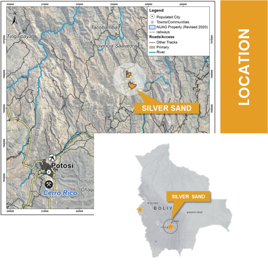
Location
Silver Sand is composed of four concession areas of North and South blocks totaling ~6 km².
The project is 4,050 m above sea level and is approximately 25 km northeast of the world-famous Cerro Rico silver and base metal mineral system near Potosi.
Access is relatively easy with a road distance of 54 km to Potosi, of which 27 km are paved road (the Bolivia National Highway 5). The rest is year-round gravel road for mining purpose of the Colavi mining district.
History, Geology, Mineralization
Silver Sand Property is one of the earliest mineral discoveries in Bolivia, before the discovery of Cerro Rico in the mid-1500’s. Silver was mined in the core area of our Silver Sand Property by Spanish Colonials since the early 16th century until the end of 19th century. Thereafter, tin was mined from Colavi and Canutillos during the Tin Baron period and until the time of the tin price crash in 1985. There are widespread small mine workings, artisanal mining dumps and numerous abandoned miners’ villages within the property.
NI-43101 Technical Report
On April 14, 2020, the Company released the inaugural NI 43-101 Mineral Resource estimate for the Project: Using a 45 g/t silver cut-off-grade the estimate reported Measured & Indicated resource tonnes of 35.39 Mt at 137 g/t Ag for 155.86 Moz and Inferred resource tonnes of 9.84 Mt at 112 g/t Ag for 35.55 Moz (see News Release dated April 14th for details). Highlights of the Resource Estimate are as follows:
-
Mineralization starts at or near-surface and is amenable to potential open-pit mining extraction: Approximately 70% of the resources are within 200 m of the conceptual open pit surface.
-
Favourable initial metallurgical test work indicates laboratory-based recoveries of up to 97% for the various oxide – transition and sulphide mineral domains (see news release dated August 23, 2019 for details).
-
Resource estimate excludes the recently discovered Snake Hole zone where drilling intercepted 72.4 m grading 279 g/t Ag (see news release dated January 13, 2020 for details).
-
Mineralization remains open to the North and South and at depth. No feeder zones or source intrusions have been discovered to date.
The Technical Report, titled “Silver Sand Deposit Mineral Resource Report” dated May 25, 2020 (effective date of January 16, 2020) has been prepared by AMC Mining Consultants (Canada) Ltd. (“AMC”), and is available under the Company’s profile on SEDAR at www.sedar.com.
For quick access click here.
Working with Excellents
Lorem ipsum dolor sit amet, consectetur adipisicing elit, sed do eiusmod tempor incididunt ut labore et dolore magna aliqua.
3200
Building
1900
Travel
4000
Global
2600
Solar
Mineral Concessions & Ownership
The Core Silver Sand mineral area is a total of 3.17 square kilometers. According to the new Mining and Metallurgy Law 535 enacted in May 2014 in Bolivia, all ATE’s must be converted to Mining Administrative Contracts (CAM) with Jurisdictional Administrative Mining Authority (Autoridad Jurisdiccional Administrativa Minera, “AJAM”).
New Pacific submitted to AJAM all required documents for the consolidation and conversion through its wholly owned subsidiary Minera Alcia S.A. in February 2018.In January 2020, the CAM conversion was approved by AJAM. In addition, New Pacific acquired 100% interest of two local private miners who owned three mineral concessions (North blocks) which are in the conversion process of CAM for an area of 5.42 square kilometers.
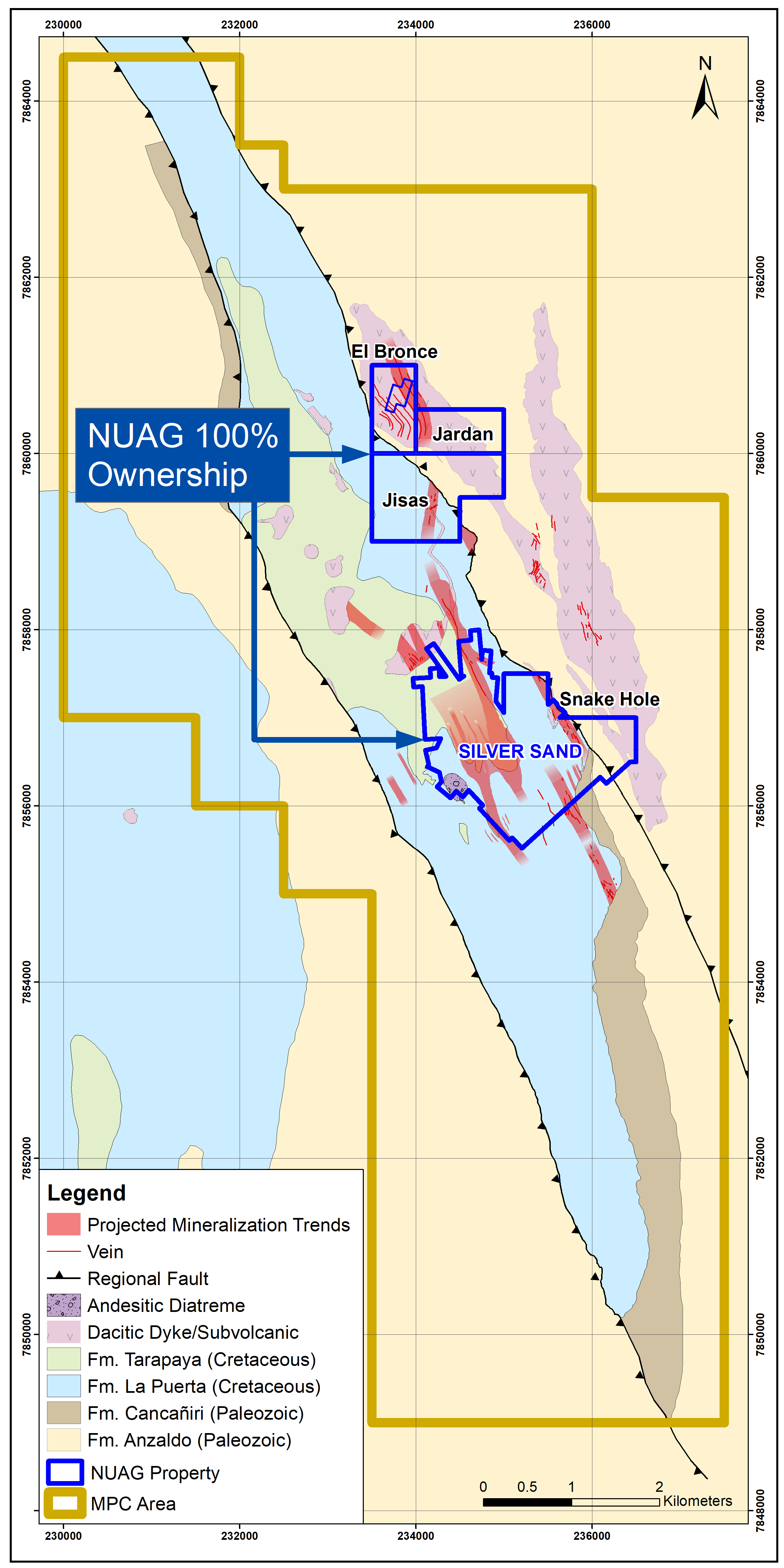
New Pacific, through its wholly owned subsidiary Minera Alcira S.A., entered a Mining Production Contract (“MPC”) with the Bolivian Mining Corporation (“COMIBOL”) in Potosi, Bolivia on January 11, 2019. The MPC covers 29 ATE’s and 201 Cuadriculas are owned by COMIBOL, for a total area of about 57 square kilometers surrounding Silver Sand core area. Effectively, New Pacific has full exposure to the district potential of silver mineralization in a broad area of more than sixty square kilometers.

Learn More
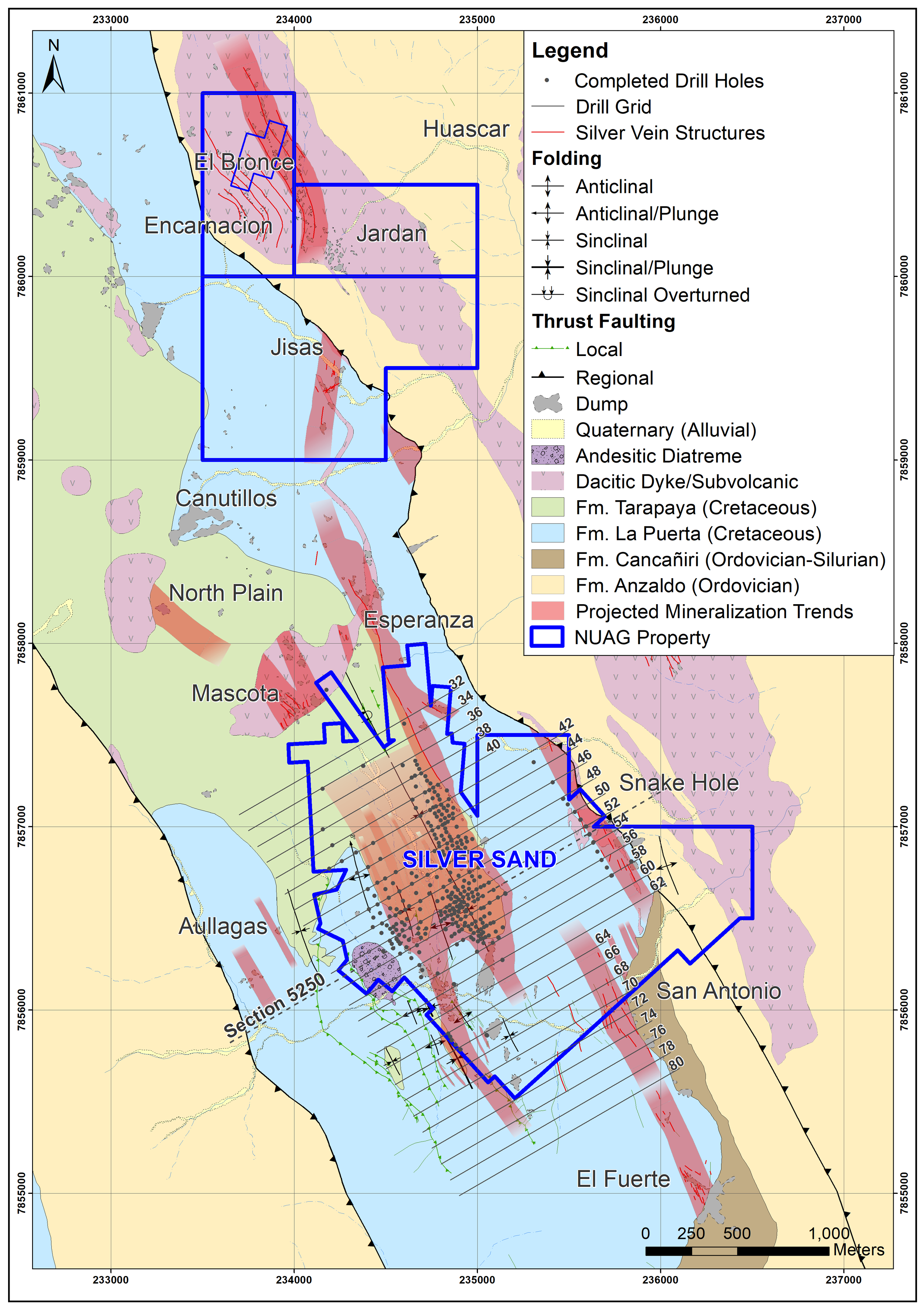
Exploration Potential at Silver Sand
The Snake Hole prospect is located approximately 600 metres east of the core area of the Silver Sand Project and consists of artisanal underground workings on structures that trend NNW-SSE. The workings and associated surface mine dumps were started in the Spanish colonial era and have continued sporadically to recent times. The workings are developed in altered (bleached) quartz sandstones and are traceable over more than 1,000 metres strike length with widths varying from a few metres up to 100 metres extent. Geochemical sampling of the workings and mine dumps returned encouraging results typically ranging from 100g/t Ag to 300g/t Ag.
Surface mapping suggests that the mineralized fracture zone remains open to north where it potentially trends undercover towards the Company’s Jisas prospect located approximately two kilometres to the northwest.
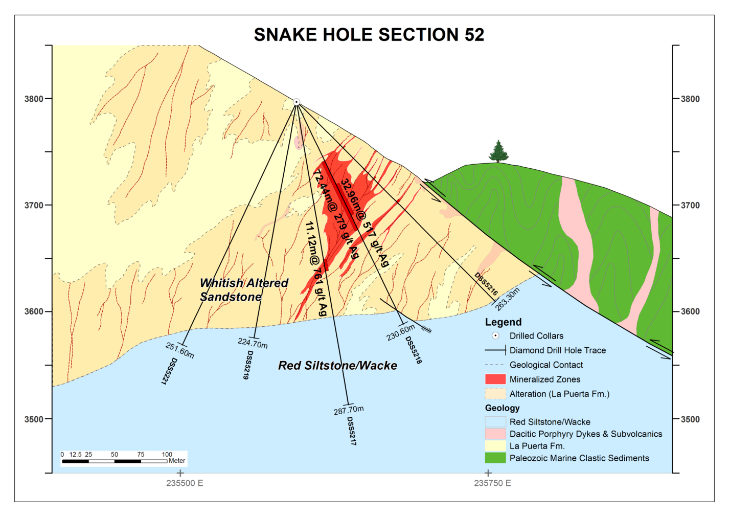
Exploration drilling commenced in late August 2019 and a total of 24 drill holes were completed by December 2019 for ~6,000 metres. The drill holes are predominantly oriented north 60 degrees east with dips varying from 45 degrees to 80 degrees. This initial campaign has provided a drill test of circa 750 metres of the structural zone with the results released covering approximately 400 metres of the southern portion of the Snake Hole structural trend as currently defined.
The majority of the drill holes have intersected silver mineralization as characterized by coarse grains of sulfosalts (freibergite) in fractures of bleached sandstones with associated disseminated pyrite. Grade and thickness of mineralization increases to the north.
Drill highlights are as follows:
-
DSS5218 – 72.44m @ 279g/t Ag from 60.5m to 132.94m including 32.96m @ 517g/t Ag from 84.95m to 117.9m;
-
DSS525020 – 38.4m @ 143g/t Ag from 29.9m to 68.3m including 6.2m @ 749g/t Ag from 36.8m to 43.0m; and
-
DSS5217 – 11.12m @ 761g/t Ag from 149.48m to 160.
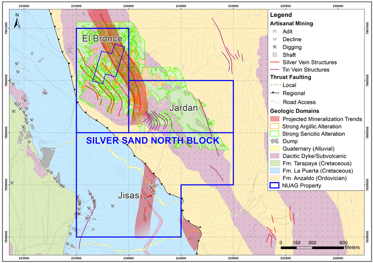
Silver Sand North Blocks (El Bronce, Jardan, Jisas)
El Bronce, Jardan, Jisas are the 3 northern blocks of the Silver Sand core area. There have been numerous ancient workings and dumps, similar to the core area of Silver Sand. 2019 surface grab samples from El Bronce returned up to 1000ppm Ag.