08 Nov, 11

New Pacific Metals Reports High Grade Assays At The Mt Skukum Gold Deposit Of Its Tagish Lake Gold Project

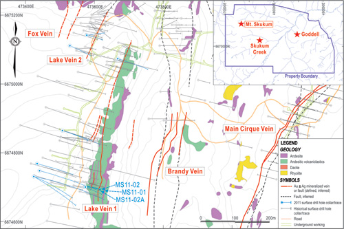
VANCOUVER, BRITISH COLUMBIA – (November 8, 2011) – New Pacific Metals Corp. (TSX-V: NUX) (the “Company”) is pleased to announce the assay results of the first three holes drilled (MS11-01, MS11-02 and MS 11-02A) in 2011 at the Lake Vein of the Mt. Skukum gold deposit at the Tagish Lake Gold Project in the Yukon Territory, Canada. Please refer to the following map for the location of the three drill holes:


nr_2011_11_08_nr.jpg

The assay results confirmed the high-grade gold mineralization of the Mt. Skukum deposit reported by 1980’s historical drilling. This zone is not currently reported in any of the Company’s resource tabulations, yet shows promise to add resources to the project. The assays are summarized below:

Table-1   Drill Intercepts at the Lake Vein of Mt Skukum in 2011

hole_id depth_from depth_to interval (m) Au_g/t Ag_g/t
MS11-01 41.15 60.10 18.95 14.66 37.9
including 41.15 53.40 12.25 21.13 50.0
MS11-02 56.00 62.57 6.57 7.57 24.8
including 57.58 59.00 1.42 21.80 70.5
MS11-02a 54.50 60.00 5.50 19.96 76.9
including 56.10 58.70 2.60 39.75 152.8

Cutoff of 1.0 g/t Au is used in calculation of intercepts. Interval is close to true width as drill is almost normal to the dip and strike of veins.

Mt Skukum is a high-level low sulfidation epithermal gold deposit characterized by high-grade auriferous quartz-calcite-adularia veins, hosted in Tertiary andesitic volcanic rocks. The deposit hosts multiple mineralized veins. The historic Mt. Skukum Gold Mine mined 233,400 tons of ore from 1986 to 1988, producing 77,790 ounces of gold from the Main Cirque Vein which is one of the related veins to this system. 

In the 1980’s, drilling and underground development were completed at the Lake Vein (as well as other veins). The Company reviewed the historical exploration data and concluded that the deposit was not adequately explored. Consequently, the Company initiated a surface drill program at the Lake Vein in the summer of 2011; 16 holes were completed totaling 2,482 meters. The aim was to confirm the high-grade nature of the mineralization, to infill drill the gap areas of historical data, and to define potential step-outs of the high grade pockets demonstrated by historical drilling. Drilling occurred between September 8, 2011 and October 1, 2011. Stock-work vein zones of quartz-calcite-adularia veins of various widths were hit. In addition, wide zones of disseminated sulphides dominated by fine pyrite and pyrrhotite in altered volcanic tuff were noticed beneath the vein zones.

The Company is very pleased with the results from the stockwork vein zones of the first three drill holes. The Company is planning future drilling to fully explore the potential of the deposit and to fully define and calculate these potential additional resources. The assay results of the disseminated sulphide zones and other holes are pending.

Quality Control
Drill cores were halved by diamond-blade saw with half core samples being shipped to the ALS Minerals (ALS) preparation lab in Whitehorse, Yukon. The assay work was completed at the ALS assay lab in North Vancouver, British Columbia.  Analysis methods are standard fire assay by AA finish and GRAV finish for gold, aqua regia digestion in addition to AA finish for silver.  Standard reference materials, blank and field duplicate samples were inserted prior to shipment to monitor the quality assurance and quality control of the assay data.

About New Pacific Metals Corp.

New Pacific Metals Corp. is a Canadian near-term gold and silver production mining company engaged in the exploration and development of gold poly-metallic properties in the Yukon, Canada. The Company’s only project is the Tagish Lake Gold Property in Yukon Territory.  With experienced management and sufficient technical and financial resources, the Company is well positioned to build shareholder value through discovery, exploration and resource development.

Jason Nickel, P.Eng. Vice President Engineering of the Company, is a Qualified Person pursuant to NI 43-101 and has reviewed and given consent to the technical information of this press release. 

For more information about New Pacific, visit New Pacific’s website at www.newpacificmetals.com or contact New Pacific Metals Corp., Jason Nickel, Vice President Engineering, Phone: (604) 669-9397, Fax: (604) 669-9387, or  New Pacific Investor Relations at 604-633-1368 or send inquires to info@newpacificmetals.com.

Neither the TSX Venture Exchange nor its Regulation Services Provider (as that term is defined in policies of the TSX Venture Exchange) accepts responsibility for the adequacy or accuracy of this release.

31 Oct, 11

New Pacific Metals Corp. Announces Assay Results Of 20.2 Meters @ 7.08 G/T Au, 143.95 G/T Ag, And 9.7 Meters @ 8.43 G/T Au, 322.26 G/T Ag

VANCOUVER, BRITISH COLUMBIA – (October 31, 2011) – New Pacific Metals Corp. (TSX-V: NUX) (the “Companyâ€�) is pleased to announce assay results from the recently completed 2011 underground drilling program at the Skukum Creek gold-silver deposit and surface drilling at the Raca prospect of its Tagish Lake Gold Project in Yukon (see the Company’s news release dated as at October 25, 2011).

Highlights of the most prominent drill results include (note – widths are core length not true widths):

  • 8.23m @ 6.52 g/t Au, 321.81 g/t Ag, 1.0% Pb and 1.52% Zn from 89.08 meters to 97.31 meters, including 2.62m @ 16.63 g/t Au, 853.33 g/t Ag, 2.51% Pb and 2.94% Zn from 90.48 meters to 93.1 meters in the hole SC11-05-UG.

  • 9.65m @ 8.43 g/t Au, 322.26 g/t Ag, 1.18% Pb and 1.63% Zn from 81.83 meters to 91.48 meters, including 6.26m @ 11.34 g/t Au, 434.15 g/t Ag, 1.48% Pb and 1.79% Zn from 81.83 meters to 88.09 meters in the hole SC11-07-UG.

  • 20.15m @ 7.08 g/t Au, 143.95 g/t Ag, 0.71% Pb and 0.99% Zn from 103 meters to 123.15 meters, including 6.8m @ 12.94 g/t Au, 225.32 g/t Ag, 1.23% Pb and 1.12% Zn from 113.7 meters to 120.5 meters in the hole SC11-13-UG.

Underground Drilling at Skukum Creek

Skukum Creek is a mesothermal quartz sulphide vein type gold-silver deposit hosted in Cretaceous granodiorite. The deposit is comprised of a few separate sub-vertical mineralized veins with the prominent one called the Rainbow Zone. Historically from 1985 to 2008, a total of 348 diamond drill holes were completed with a total meterage of 44,097 meters, plus a total of 4,050 meters of underground tunnel development. Underground drilling in 2011 was carried out at the south end of the Xcut-3 of the 1300m level, targeting an area about 150 meters long by 60 meters wide of the Rainbow Zone near the bottom of the 1225m ramp. The program aimed to confirm both the high grade intercepts evidenced by the historical hole 86-R8 which yielded 2.95m @ 30.01 g/t gold and 603.55 g/t silver, historical hole 87-UG17R which had 25.6m @ 11.24 g/t gold and 291.78 g/t silver including 8.29m @ 28.19 g/t gold and 748.54 g/t silver, and to infill drill this area to upgrade the confidence in the resources. This high grade area could be a “starter pocket� for an initial bulk sampling program to study metallurgy and other parameters, if it is confirmed by the drilling. A total of 1,709.3 meters in 14 holes were drilled from July 23 to August 19, 2011 with one hole abandoned. Assay results of the 13 completed holes are as follows:

Table-1  Drill Intercepts at Skukum Creek Underground Drilling in 2011

hole_id
depth_from
depth_to
interval (m)
Au_g/t
Ag_g/t
Pb_%
Zn_%
SC11-01-UG
85.76
90
4.24
3.23
135.57
0.59
0.65
SC11-02A-UG
88.9
91.17
2.27
3.3
93.59
0.58
0.54
SC11-03-UG
76.65
78.54
1.89
3.44
95.72
0.30
0.47
81.51
82.55
1.04
1.93
90.4
0.68
0.72
SC11-04-UG
81.35
85.76
4.41
3.02
122.09
0.52
0.73
87.65
89.21
1.56
4.99
126.68
0.28
0.43
92.3
94.62
2.32
4.9
54.98
0.30
0.54
SC11-05-UG
89.08
97.31
8.23
6.52
321.81
1.10
1.52
Including
90.48
93.1
2.62
16.63
853.33
2.51
2.94
 
103.8
105.9
2.1
1.61
43.88
0.57
0.28
 
108.64
110
1.36
5.1
27
0.13
0.18
SC11-06-UG
123
124.11
1.11
4.28
378
0.74
0.50
142.08
143.08
1
1.18
3.2
0.01
0.18
SC11-07-UG
81.83
91.48
9.65
8.43
322.26
1.18
1.63
Including
81.83
88.09
6.26
11.34
434.15
1.48
1.79
 
101.72
103.96
2.24
16
406.88
1.54
2.66
SC11-08-UGÂ Â Â Â Â
74.8
83
8.2
2.2
53.27
0.24
0.47
86.6
89
2.4
2.63
11.07
0.07
0.20
SC11-09-UGÂ Â Â Â Â
78
79.7
1.7
4.14
119.77
0.22
0.23
83.9
91.25
7.35
2.34
22.37
0.14
0.19
93.4
96.42
3.02
2.09
33.98
0.24
0.29
SC11-10-UGÂ
61
63
2
1.82
44.09
0.21
0.36
 
65
71.1
6.1
2.75
34.1
0.16
0.43
Including
65
67.05
2.05
5.3
61.4
0.29
0.73
SC11-11-UG
68.82
73.48
4.66
2.04
174.44
0.56
0.83
75.48
77.48
2
1.27
28
0.21
0.40
SC11-13-UG
103
123.15
20.15
7.08
143.95
0.71
0.99
Including
113.7
120.5
6.8
12.94
225.32
1.23
1.12
SC11-15-UG
94.42
95
0.58
5.85
198
0.86
1.41
 
97.85
113.65
15.8
2.58
70.12
0.29
0.45
Including
105.52
107.58
2.06
5.67
53.44
0.23
0.52

Cut off of 1.0g/t Au is used in calculation of intercepts.
True thickness is around 50-80% of drill intercepts depending on the drill angles.

The Company is pleased the mineralization of the Rainbow Zone was confirmed by the underground drilling, which is planned to resume with the renewal of its exploration license.

Surface Drilling at Raca

The Raca prospect is located along the northeast structural extension of the Skukum Creek mineralization zones (Rainbow zone), and the Chieftain Hill site is located at the northeast extension of the Raca prospect.

Mineralization at Raca is characterized by quartz sulphide veins and breccia containing high grade silver, hosted along the contacts of a rhyolite dyke with volcanics in the hanging wall, and Cretaceous K-feldspar megacrystic Bennett granite in the footwall. Typically at Raca, less gold base metal grades are seen. Four holes were historically drilled totalling 1050.34 meters in 1986 and 1997, with the best intercept of 3.61m @2.66g/t gold and 561.37g/t silver from the hole RACA97-1. Drilling in 2011 at Raca was aiming to test the deep extension and strike extent of the known mineralization zone for which about 3,900 meters of core drilling was planned at the beginning of this year. Drilling started on June 26, 2011 and terminated on July 31, 2011. A total of five holes totalling 1,251.45 meters were drilled with two holes completed to planned depth and the rest abandoned due to down-hole problems, such as thick overburdens and fault zones in tuffaceous andesite horizon. Both the two completed holes hit mineralization zones at planned depth; the first hole,  Raca11-01,  hit a new zone of high grade silver in the hanging wall volcanics (see the Company’s news release dated as at August 2, 2011). Assay results are summarized as follows:

Table-2  Drill Intercepts at Raca Surface Drilling in 2011

hole_id
depth_from
depth_to
interval (m)
Au_g/t
Ag_g/t
Pb_%
Zn_%
Remark
Raca11-02
134.21
135.4
1.19
0.75
300
0.17
0.3
Zone 2
183.58
184.46
0.88
0.19
190
0.13
0.14
Raca11-03
abandoned, failed to reach target
Raca11-04
abandoned, failed to reach target
Raca11-05
abandoned, failed to reach target

Cut-off grade of 50g/t Ag is used, true thickness is about 75% of drill intercepts.

Due to down-hole problems and limited field operational time window, only two of the five holes were completed to the planned depth. The Company is pleased that both of the two completed holes hit high grade mineralization at targeted depth. However, the potential of down-dip and along strike of the mineralization zones at Raca still remains to be fully tested.

Drill cores were halved by diamond saw with half core samples being shipped to the preparation lab of the Stewart Group in Whitehorse, Yukon for preparation, and then being assayed at the assay lab of the Stewart Group in Kamloops, British Columbia. Analysis methods are standard fire assay by AA finish for gold, aqua regia digestion plus AA finish for silver and base metals. Standard reference materials, blank and field duplicate samples were inserted prior to shipment from site to monitor the quality assurance and quality control of the assay data.

The Company would also like to clarify one point from its October 25, 2011 news release – the Company, through its subsidiary Tagish Lake Gold Corp, has applied for a permit for a Class 3 Exploration program as set out under the Quartz Mining Land Use Regulation, (Yukon) Dec 31/05.

About New Pacific Metals Corp.

New Pacific Metals Corp. is a Canadian near-term gold and silver production mining company engaged in the exploration and development of gold poly-metallic properties in the Yukon, Canada. The Company’s only project is the Tagish Lake Gold Property in Yukon Territory. With experienced management and sufficient technical and financial resources, the Company is well positioned to build shareholder value through discovery, exploration and resource development.

Jason Nickel, P.Eng. Vice President Engineering of the Company, is a Qualified Person pursuant to NI 43-101 and has reviewed and given consent to the technical information of this press release.Â

For more information about New Pacific, visit New Pacific’s website at www.newpacificmetals.com or contact New Pacific Metals Corp., Jason Nickel, Vice President Engineering, Phone: (604) 669-9397, Fax: (604) 669-9387, or New Pacific Investor Relations at 604-633-1368 or send inquires to info@newpacificmetals.com.

Neither the TSX Venture Exchange nor its Regulation Services Provider (as that term is defined in policies of the TSX Venture Exchange) accepts responsibility for the adequacy or accuracy of this release.

25 Oct, 11

New Pacific Metals Corp. Reports Exploration Activities At The Tagish Lake Gold Project

VANCOUVER, BRITISH COLUMBIA – New Pacific Metals Corp. (TSX-V: NUX) (the “Companyâ€�) is pleased to announce the successful completion of 12,488 meters of diamond drilling in 51 holes, including 37 surface drill holes and 14 underground drill holes, from June 28 to October 1, 2011 at the Tagish Lake Gold Project in the Yukon, Canada (the “Projectâ€�).  Core from this drilling has all been logged and processed and most assay results are still pending. The Company is experiencing longer wait times for its assay results as the Stewart Group, the assay laboratory completing the assay results, is in the process of being acquired by the ALS Chemex. Â

Permitting Update & Project Status

All exploration activities at the Project site ceased as at October 11, 2011 as the Project’s current Class 3 Quartz Mining exploration license (“QMLâ€�) expired on that day. The Company has applied for a new QML, along with a Class B Water Use License (WUL) in March 2011 and the Company’s applications are currently being reviewed by Yukon regulators.   The Company expects the regulatory process to be completed in 2011 at which point the Company will continue further exploration work.

During this interim period, the camp facility and offices at the Project site will remain open for the winter months with the access roads being maintained in anticipation of a new QML. Also, the Company is completing an “active reclamation planâ€�, including site audit and general site clean-up. Â The Company will also continue to work on environmental baseline studies as well as biological studies to support its permitting process and feasibility studies to effect a 300 to 600 tonnes per day high grade mining operation. Â

Summary of Exploration Activities 2011

The exploration field season at the Tagish Lake Gold Project commenced on May 18, 2011, after expansion of the Project site camp from 25 to 50 persons was completed, and continued to October 9, 2011. The field activities were comprised of prospecting, surface geological mapping, soil surveying, surface drilling, underground diamond drilling, as well as supplementary sampling of historical drill cores. Other work to support the exploration program, included camp upgrading, road repair and construction, underground rehabilitation, dewatering and “de-icing,� water sampling,  staking new claims, and satellite image processing of the entire Project site.

Summary of the completed exploration physicals is as set out in the table below:

Table 1: Summary of Exploration Program

 
Holes
Meters
Surface drilling
37
10,778.47
Underground drilling
14
1,709.3
Sub-total
51
12,487.77
Surface mapping 1.8 square kilometers at Raca-Chieftain Hill
Surface sampling 293 rock chip samples, 25 grab samples,
180 soil samples and 2 talus samples
Supplementary core sampling 314 samples from 50 holes
Road repair and construction 32.3 kilometers of road repaired; and
2.46 kilometers new road constructed
Underground de-watering and refurbishment 460 meters
Water sampling 348 samples
Staking 571 claims
Image processing 276 square kilometers

Supplementary Sampling of Historical Drill Core

Prior to the commencement of drilling this year, a supplementary sampling program was carried out in the historical drill cores of Goddell and Raca zones. A total of 314 samples from 50 holes were completed. Assays did not return any significant results.

Surface Geology Mapping, Prospecting and Sampling

Before drilling started in 2011, the site geology team implemented a program of surface prospecting, mapping and sampling at Raca-Chieftain Hill, Carbon Hill, Charleston, Mt McNeil and Tango. A total of 500 samples were taken including 180 soil samples, 293 chip samples, 25 grab samples, and two talus samples. The strong linear gold soil anomaly at Chieftain Hill was confirmed by this sampling activity. Additionally, 1.8 square kilometers of geology mapping was completed at the Raca-Chieftain Hill corridor area and the geological structure was re-interpreted.

Road Repair and Construction

There are extensive road accesses across the Project site. Most of the roads were built in the 1980’s and required refurbishment prior to use and as such the Company repaired 32.3 kilometers of old road. The Company built only 2.46 kilometers of new road, mainly on Chieftain Hill with a section at Antimony Creek.

Underground Dewatering and “De-icing�

To provide access for underground drilling, the Company planned dewatering at the 780 meter long decline at Goddell. However, due to unexpected ground conditions, only the first 130 meters of the decline was dewatered and refurbished. At the 1300 meter level tunnel at Skukum Creek, a total of 330 meters of the portal was rehabilitated, with rebar rock-bolting, removal of the ice from the tunnels, and mine services refurbishment being conducted.

Water Sampling

As part of the environmental baseline study and its current regulatory requirements, the Company completed a total of 348 samples taken from 12 water stations from mid April 2011 to October 10, 2011. The sampling program was supervised by Access Consulting of Whitehorse, Yukon.

Staking

In April 2011, the Company staked a total of 571 new claims. The new staking expands the Company’s ground position in the Wheaton river area.

Satellite Image Processing

To facilitate exploration activities, the Company retained MDA Geospatial Services Inc., of Richmond, British Columbia to generate digital topographic base maps using high resolution Geo Eye satellite images. The new digital topographical maps cover an area of 276 square kilometers showing both new existing claims.

Underground and Surface Drilling

A. Skukum Creek

14 underground drill holes (see Table 2) totaling 1,709.3 metres were completed at the Skukum Creek 1300 metre level tunnel to target some high grade pockets with a plan to initiate a possible bulk-sample program. Underground drilling was halted after the 14 holes were completed; the previous owners’ equipment for such drilling was deficient. Once the new permit is granted, the Company intends to continue its drilling program with more effective equipment.

Table 2: List of Underground drill holes drilled at Skukum Creek

Hole_ID
UTM_East
UTM_North
Elevation
Azimuth
Dip
EOH
(meters)
Status
SC11-01-UG
477795.235
6671262.217
1302.918
11.4
-56.5
140.90
completed
SC11-02-UG
477795.235
6671262.217
1302.918
14
-60.6
140.10
completed
SC11-03-UG
477795.055
6671262.484
1303.106
4.5
-55.45
110.50
completed
SC11-04-UG
477795.042
6671262.445
1303.036
8.4
-63
130.00
completed
SC11-05-UG
477794.981
6671262.433
1303.008
12.6
-69
134.50
completed
SC11-06-UG
477795.524
6671261.752
1302.989
19
-73.4
161.40
completed
SC11-07-UG
477793.429
6671261.508
1302.862
359.6
-70.3
131.40
completed
SC11-08-UG
477793.368
6671261.68
1302.864
358.3
-65.2
122.30
completed
SC11-09-UG
477792.869
6671260.106
1302.857
335.4
-76.5
134.40
completed
SC11-10-UG
477792.869
6671260.106
1302.857
332
-68.2
116.10
completed
SC11-11-UG
477793.195
6671260.45
1302.849
348.5
-62.5
101.10
completed
SC11-13-UG
477795.564
6671261.976
1303.216
22.5
-54
140.00
completed
SC11-15-UG
477795.564
6671261.976
1303.216
17.5
-57
141.00
completed
SC11-14-UG
477793.8
6671263
1302
16
-51
5.60
abandoned
sub-total


1,709.30


Six surface drill holes (see Table 3) totaling 3,157 metres have been completed for the Skukum Creek area to test down-dip extension of previous underground drilling.

Table 3: List of Surface Drill holes for Skukum Creek

Hole_ID
UTM_East
UTM_North
Elevation
Azimuth
Dip
EOH
(meters)
Status
SC11-01
477945.459
6671171.352
1444.589
327
-63.5
400.83
completed
SC11-02
477945.445
6671171.221
1444.471
315
-74
551.44
completed
SC11-03
477945.488
6671171.505
1444.732
290
-65
449.55
completed
SC11-04
477945.879
6671171.962
1444.58
291
-70
617.50
completed
SC11-05
477945.946
6671172.144
1444.607
299
-75
632.12
completed
SC11-06
478102.302
6671140.55
1368.328
331
-60
506.07
completed
sub-total


3,169.51
 

B. Goddell

The main priority for drilling at Goddell was to test areas around the zone intercepted by drill hole 97-41 (intercepted 64.69 metres grading 5.75 grams per tonne gold), (see the Company’s press release as at January 13, 2011).

The majority of drilling was planned as underground drilling from the existing Goddell tunnel, as underground drilling can be completed year round and such drilling substantially reduces total drilling meters as opposed to drilling from surface.  Accordingly, at the beginning of the season, the Company dewatered and rehabilitated the tunnel. However, as the project progressed the Company found that the ground conditions in Goddell were difficult; with faults of two to three metres requiring extensive support. After incurring $500,000 to rehabilitate the tunnel, the Company stopped further work, to re-assess the costing and value of the current plan. The Company intends to effect a new plan for next year’s exploration program.

Surface drilling at the Goddell started in mid-July.  To reach the planned targets, holes of 550 meters were planned. A total of eight holes were completed, totaling 3,187.02 meters, (see Table 4) of which three holes totaling 1951.86 meters were drilled to the planned depth;  the remaining holes being abandoned for various reasons including drill pad depression caused by excessive rain  and poor drilling performance. The completed holes have all successively hit wide zones of disseminated sulphide mineralization. This mineralization is hosted in altered andesite and rhyolite dykes, breccia zones and quartz monzonite, characterized by fine pyrite and shiny acicular arsenopyrite.

Table 4: List of Surface Drill Holes completed and abandoned at Goddell

Hole_ID
UTM_East
UTM_North
Elevation
Azimuth
Dip
EOH
(meters)
Status
GG11-01
484093.96
6672880.13
1188.27
110.5
-47.3
369.11
abandoned
GG11-02
484051.508
6672904.502
1176.307
110
-45
633.44
completed
GG11-03
484051.606
6672904.641
1176.316
107
-45
325.18
abandoned
GG11-04
484051.204
6672904.682
1176.242
110.5
-50
638.10
completed
GG11-05
483729.8
6673089
1017.31
180
-62
24.90
abandoned
GG11-06
484045.125
6672906.065
1175.953
143
-67
680.32
completed
GG11-09
484045.21
6672906.046
1175.662
108
-72
160.58
abandoned
GG11-10
484045.159
6672905.784
1175.944
108
-66
355.39
abandoned
sub-total


3,187.02
 

C. Raca and Chieftain Hill

The Raca site is located along the northeast structural extension of the Skukum Creek mineralization zones (Rainbow zone). Chieftain Hill site is located at the northeast extension of the Raca.
The main focus of surface drilling at Raca was to test the extension of known historical drilling, where drill hole, Raca 97-1, intercepted 3.6 metres grading 2.66 grams per tonne gold and 561 g/t silver, and to test at least four parallel mineralized structures.

Drilling started on June 26 and terminated on July 31. A total of five holes totaling 1,251.45 meters were drilled (see Table 5) with two holes completed at planned depth; the rest were abandoned due to downhole problems caused by thick overburdens and fault zones in tuffaceous andesite horizon. Both completed holes hit mineralization zones at planned depth; the first hole Raca11-01 hit a new zone of high grade silver in the hanging wall volcanics (see the Company’s news release as at  August 2, 2011).  Further assay results from this drilling are still pending. The Company is planning further drilling in this area in the future.

To make better use of the weather limited time window at the Project site, drilling at Raca was stopped and the drill rig was moved to Chieftain Hill.

At Chieftain Hill the Company wanted to test soil gold anomalies outlined by a previous owner (all associated with anomalously high values of silver and base metals). Such anomalies covered a corridor two kilometres long by 500 metres wide with peak values of up to 1,000 parts per billion gold (1 gram/tonne or “g/t�).

The Company confirmed these soil gold anomalies by completing a soil-sampling program, which recorded soil gold anomalies up to 0.3 g/t gold associated with lead and zinc contents of up to 0.4%. Also, to further test these anomalies, three holes were planned to cover a strike extent of 300 meters and vertical extent of 300 meters from surface. Due to difficult drilling conditions at the top of the Chieftain Hill, only one hole (CFT11-01) was eventually completed at depth of 346.83 meters (see Table 6), at which point, the rig was moved to the Rainbow Zone at Skukum Creek.

Table 5: List of Surface drill holes at Raca

Hole_ID
UTM_East
UTM_North
Elevation
Azimuth
  Dip  
EOH
(meters)
Status
RACA11-01
478317.68
6671615.188
1232.568
325
-61
350.55
completed
RACA11-02
478317.347
6671615.669
1232.573
325
-45
216.41
completed
RACA11-03
478498.322
6671509.106
1215.2
308
-56
170.14
abandoned
RACA11-04
478500.297
6671507.23
1215.064
308
-60
310.14
abandoned
RACA11-05
478394.392
6671572.378
1225.527
310
-68
204.21
abandoned
sub-total


1,251.45
 

Table 6: List of Surface drill holes at Chieftain Hill

Hole_ID
UTM_East
UTM_North
Elevation
Azimuth
  Dip  
EOH
(meters)
Status
CFT11-01
478904.488
6672506.587
1791.915
120
-60
346.83
completed

D. Lake Vein of Mt. Skukum

The Lake Vein of Mt. Skukum is a high grade gold-silver epithermal deposit characterized by quartz-calcite-adularia vein filling in open space fractures in Tertiary andesitic rocks. Extensive surface and underground drilling were completed in the 1980’s to delineate the deposit. Drilling began on September 8 and finished on October 1. A total of 2,482.66 meters of drilling were completed in 16 holes in Quartz-calcite-adularia veins of various width were hit in holes (see Table 7). In addition, wide zones of disseminated sulphides dominated by fine pyrite and pyrrhotite in altered volcanic tuff were observed. The assay results are pending.

Table 7: List of Surface Drill Holes at Lake Vein of Mt. Skukum

Hole_ID
UTM_East
UTM_North
Elevation
Azimuth
  Dip  
EOH
(meters)
Status
MS11-01
473575.288
6674703.979
1905.272
106
-50
81.00
completed
MS11-02
473574.991
6674703.971
1905.256
106
-66
100.53
completed
MS11-02A
473573.82
6674701.219
1905.274
106
-60
90.00
completed
MS11-03
473573.952
6674701.818
1905.32
96
-61
100.45
completed
MS11-04
473573.635
6674700.467
1905.242
117
-61
102.00
completed
MS11-05
473423.92
6674731.074
1926.42
106
54
345.00
completed
MS11-06
473423.92
6674731.074
1926.42
128
-51
206.00
completed
MS11-07
473423.92
6674731.074
1926.42
117
-55
210.00
completed
MS11-08
473440.639
6674747.729
1925.775
107
-56
243.00
completed
MS11-09
473433.412
6674768.337
1926.085
106
-59
200.10
completed
MS11-10
473506.881
6674864.506
1916.972
108
-55
189.00
completed
MS11-15
473506.468
6674864.602
1917.023
108
-64
170.00
completed
MS11-12
473667.894
6675073.146
1889.536
109
-50
138.00
completed
MS11-11
473529.066
6675110.853
1863.415
115
-53
111.00
completed
MS11-13
473578.025
6675141.68
1860.767
84
-62
106.58
completed
MS11-14
473575.7
6675141.79
1860.77
108
-58
90.00
completed
sub-total


2,482.66
 

E. Antimony Creek

The Porter structure is an east-west striking altered shear zone up to one hundred meters wide at Antimony Creek. Historical surface prospecting and soil sampling indicated precious and base metal mineralization at the surface but the zone was never drill tested. Three holes were planned in order to test the depth potential along the structure this year. Drilling (hole ATM11-01) was started on September 26 and abandoned at the depth of 341 meters on September 30 because of excessive hole bending; this was far short of the target depth of 450 to 500 metres (see Table 8).  A wide altered shear zone with local disseminated sulphides intervals was identified in the drill core and the assay results are pending. The potential of the major Porter structure still requires further exploration.

Table 8: List of Surface Drill Holes at Antimony Creek

Hole_ID
UTM_East
UTM_North
Elevation
Azimuth
  Dip  
EOH
(meters)
Status
ATM11-01
483653.447
6670862.606
1350.084
167.5
-64
341.00
abandoned

Occupational Health and Safety Update

During the summer, the Project received orders from Yukon Workers Compensation Health and Safety Board.  Such orders were to remedy situations such as equipment deemed not to have met the regulatory standards (including mechanical deficiencies of underground mining equipment which was not owned by the Company).  All such equipment has since been removed from the Project, and the Company is currently sourcing new equipment that meets or exceeds all current Yukon regulations.

New Management

The Company is pleased to announce that Jason Nickel, P.Eng., Vice-President of Engineering, has joined the Company as of September and is currently leading the Project and directing engineering evaluations, economic evaluations, and development plans at the Project site.  

Jason has been involved in advancing several projects in British Columbia, Yukon and Northwest Territories. Most recently he was the Mine Manager of Capstone’s Minto mine in the Yukon. Mr. Nickel has spent much of his career in engineering and mine operations. He has a B.Sc. from the University of British Columbia in Mine Engineering.

Grant of options

The Company, subject to regulatory approval, has granted an aggregate of 140,000 incentive stock options to an employee of the Company. The stock options are exercisable at $1.33 for a period of five years and are subject to a vesting period of 24 months.

About New Pacific Metals Corp.

New Pacific Metals Corp. is a Canadian near-term gold and silver production mining company engaged in the exploration and development of gold poly-metallic properties in the Yukon, Canada. The Company’s only project is the Tagish Lake Gold Property in Yukon Territory. With experienced management and sufficient technical and financial resources, the Company is well positioned to build shareholder value through discovery, exploration and resource development.

Jason Nickel, P.Eng. Vice President Engineering of the Company, is a Qualified Person pursuant to NI 43-101 and has reviewed and given consent to the technical information of this press release.Â

For more information about New Pacific, visit New Pacific’s website at www.newpacificmetals.com or contact New Pacific Metals Corp., Jason Nickel, Vice President Engineering, Phone: (604) 669-9397, Fax: (604) 669-9387, or New Pacific Investor Relations at 604-633-1368 or send inquires to info@newpacificmetals.com.

Neither the TSX Venture Exchange nor its Regulation Services Provider (as that term is defined in policies of the TSX Venture Exchange) accepts responsibility for the adequacy or accuracy of this release.

05 Oct, 11

New Pacific Metals Corp. Announces Filing Of New NI 43-101 Report

VANCOUVER, BRITISH COLUMBIA – (October 5, 2011) – New Pacific Metals Corp. (TSX-V: NUX) (the “Company”) is pleased to announce it has filed a new technical report for the Tagish Lake Gold project located in the Yukon Territory, Canada. This new technical report, which has been previously reviewed by the British Columbia Securities Commission (the “BCSC”) was filed in response to the BCSC’s concerns and direction which are set out in the Company’s news release dated July 29, 2011 which is available for review on SEDAR and on the Company’s website (www.newpacificmetals.com).

The newly filed technical report is titled “TAGISH LAKE GOLD PROPERTY WHITEHORSE MINING DISTRICT NI 43 101 REPORT” dated September 2, 2011; Brian O’Connor, of AMC Mining Consultants (Canada) is an independent Qualified Person, as defined by NI 43-101, authored the report. The report is available for review on SEDAR and on the Company’s website.

The Tagish Lake Gold project is located within the Intermontane Belt of the Canadian Cordillera, and locally situated in a Tertiary subvolcanic to volcanic caldera system (Mt. Skukum Volcanic Caldera) which is underlain by a dome (or several dome) complexes. There are three known precious metal deposits on the Property: Mt. Skukum gold deposit, Skukum Creek gold-silver deposit and Goddell gold deposit. In addition, there are numerous mineral showings and geochemical anomalies within the claim block, such as the Charleston gold-silver showing, Becker-Cochran antimony mineralization, Porter-Antimony Creek silver antimony showing, and Raca gold-silver showing. The Mt. Skukum gold deposit is a high level, epithermal, auriferous, quartz-calcite, vein type gold deposit, and is hosted in open fractures in Tertiary andesitic volcanic rocks. Both grade and width of the auriferous veins change dramatically along strike and down dip with frequent swelling and pinch out. The Skukum Creek deposit is a mesothermal quartz sulphide vein type gold-silver deposit. In some documents it is also taken as the lower portion of an epithermal system. The quartz sulphide veins are hosted in Mesozoic intermediate to felsic intrusive rocks and emplaced along the contact of rhyolite/andesite dykes with intrusive rocks. The veins and dykes formed a unit which emplaced along shear zones and faults developed in intrusive rocks. Besides gold and silver, the veins contain varying amount of base metals.

Historical work on the property culminated with the discovery and resource definition of the three known deposits during the 1980s to 1990s. There are two years of gold production at the Mt. Skukum Gold Mine from 1986 to 1988 with total gold production of 77,790 ounces. Historical exploration consisted of surface geological surveys, geochemical surveys, ground and airborne geophysical surveys, trenching, and surface and underground drilling. Approximately 121,000m was drilled in more than 910 holes, and 7,630m of underground drifting and crosscutting were developed, mostly for the three deposits.

There are numerous historical estimates of resources and reserves of the deposits in Tagish completed by in-house professionals of numerous companies and third party consultants since late 1980s. The most recent estimates were made by MineTech in 2003 on the Skukum Creek deposit and Goddell deposit and a 2007 resource update on the Skukum Creek deposit. The Mt. Skukum gold deposit has a historical reserve estimate dated 1988. The following is a summary of the historical estimates. All of the following estimates are being treated as historical estimates by the Company. A Qualified Person has not done sufficient work to classify the historical estimates in this section as current mineral resources or mineral reserves. The 2003 estimates tabled are at a 3 g/t Au cutoff. The commodity prices used for the estimate were in US denomination $300 and $4.50 for Au and Ag respectively. The Au equivalent was calculated as follows: AuEq(g/t) = Au(g/t) + (Ag(g/t) X 4.50/300).

Table 1.0:Â 2003 Historical Resources Skukum Creek


1.jpg

Table 2.0:Â 2003 Inferred Historical Resources Skukum Creek


2.jpg

Table 3.0:Â 2003 Historical Resources Goddell


3.jpg

Table 4.0: 2007 Historical Resource Summary Rainbow 2 and Berg Zones:


4.jpg

The AuEq for the 2007 estimate was calculated in a similar fashion as the 2003 estimate. The commodity prices used for the estimate were in US denomination $650 and $13 for Au and Ag respectively.

Brian O’Connor.P.Geo., an Independent Qualified Person as defined by NI 43-101, has reviewed and has given consent to this press release disclosing the resource and has confirmed that this press release fairly and accurately represents the information in the technical report.

About New Pacific Metals Corp.
New Pacific Metals Corp. is a Canadian near-term gold and silver production mining company engaged in the exploration and development of gold poly-metallic properties in the Yukon, Canada. The Company’s current project is the Tagish Lake Gold Property in Yukon Territory. With experienced management and sufficient technical and financial resources, the Company is well positioned to build shareholder value through discovery, exploration and resource development.

For more information about New Pacific, visit New Pacific’s website at www.newpacificmetals.com or contract New Pacific Metals Corp., Maria Tang, CFO, Phone: (604) 669-9397, Fax: (604) 669-9387, or New Pacific Investor Relations at 604-633-1368 or send inquires to info@newpacificmetals.com Website: www.newpacificmetals.com

Neither the TSX Venture Exchange nor its Regulation Services Provider (as that term is defined in policies of the TSX Venture Exchange) accepts responsibility for the adequacy or accuracy of this release.

19 Sep, 11

New Pacific Metals Corp. Announces Results For The Fourth Quarter And Year Ended June 30, 2011

VANCOUVER, BRITISH COLUMBIA – SEPTEMBER 19, 2011: New Pacific Metals Corp. (the “Company”) announces its audited consolidated financial results for the fourth quarter and year ended June 30, 2011. All figures are expressed in Canadian Dollars (CAD$) unless otherwise stated.

FISCAL 2011 FINANCIAL HIGHLIGHTS

For the year ended June 30, 2011 (“F2011”), the Company recorded net income of $13,259,838 or $0.25 per share compared to loss of $1,751,435, or $0.06 per share for the year ended June 30, 2010 (“F2010”).  Significant highlights are as follows:

  • Income from discontinued operations of $16,253,918 as a result of gains recognized on disposition of subsidiaries during the year, compared to losses from discontinued operations of $267,420 in F2010.

  • Loss from continuing operations of $2,994,080 as a result of increased operations, compared to $1,484,015 in F2010.

  • Incurred total expenses of $3,253,255 as a result of increased stock-based compensation, foreign exchange loss, and general expenses due to increased operations, compared to $1,544,719 in F2010.

  • Completed the acquisition of the Tagish Lake Gold Property by acquiring Tagish Lake Gold Corp. and its subsidiaries for total purchase consideration of $20,392,409, comprising of shares, options and cash. The Tagish Lake Gold Property consists of 982 mineral claims covering approximately 178 square kilometres in the Yukon, Canada.

  • Successfully raised gross proceeds of $24.3 million through a private placement.

  • Incurred exploration and development expenditures of $2,621,888 at the Tagish Lake Gold Property. Assay results from such exploration are pending.

As of June 30, 2011, the Company has a working capital position of $37,232,868 (June 30, 2010 – $8,964,681).  Cash and cash equivalents amounted to $20,625,672 (June 30, 2010 – $6,333,154).  With a strong working capital, the Company is well positioned financially to continue development of the Tagish Lake Gold Property.

FOURTH QUARTER FINANCIAL HIGHLIGHTS

For the quarter ended June 30, 2011, the Company incurred a loss of $212,698 or $0.003 per share (quarter ended June 30, 2010 – $462,731 or $0.015 per share).  During this quarter, the Company recorded total expenses of $835,296, an increase of $389,526 compared to $445,770 in the same period last year.  Greater expenses were mainly due to increased stock-based compensation, foreign exchange loss, and general expenses due to enhanced exploration operations. During the quarter, the Company recognized a gain of $596,063 from disposition of a subsidiary; no such gain was recorded in the same period last year.

Fiscal 2012 year OUTLOOK and Exploration Program Budget

The Company’s focus is development of the Tagish Lake Gold Property, a property which consists of 178 square kilometres of mineral claims in the Yukon Territory, having three known deposits; Goddell Gold, Skukum Creek Gold-Silver, and Mt. Skukum Gold Projects. 

For the 2012 fiscal year, 24,000 metres of surface drilling and 36,000 metres of underground drilling (60,000 metres in total) are planned with total estimated expenditures of $16.5 million.  Fiscal 2012 planned exploration activities and expenditures are broken down as follows:

  1. Permitting ($0.85 million) – The Company has initiated an Environmental Assessment Study for the Tagish Lake Gold Property, which is required to apply for the Quartz Mining License. The Company will continue to carry out the feasibility study, using an in-house technical team combined with external consulting firms.

  2. Surface Infrastructure ($0.68 million)including expansion of the camp from 25 to 50 persons by refurbishing an 11,000 square feet camp facility already on site, refurbishing a 6,000 square feet geological office and core logging facility, and repairing some access roads. Surface infrastructure has been completed as of this reporting date.

  3. Equipment ($1.4 million) – This budget includes the purchase of generators, pumps, ventilation, electronic, communication, and camp office equipment.

  4. Underground drilling at Goddell ($4.4 million)– about 23,000 metres of underground drilling was planned at Goddell. Underground drilling will focus on the area 1,000 metres long and 600 metres down- and up-dip of the PD Zone and Merge Zones, where previous drilling, such as drill hole 97-41, intercepted 64.69 metres grading 5.75 g/t Au (please refer to January 13, 2011 Press Release).

  5. Skukum Creek underground drilling ($3.1 million) – Skukum Creek is located about six kilometres southwest from the Goddell Portal: 13,000 metres of underground drilling was planned to target depth extensions of four mineralized zones where historical drilling was limited to portions of the four mineralized zones, and only to about 300 metres from the surface. The underground drilling commenced in July 2011.

  6. Surface drilling and geophysics ($4.6 million) – a total of 24,000 metres of surface drilling was planned and surface drilling commenced at Raca in June 2011 and at Goddell in early July.

    At the Raca site, located along the structural extension of the Skukum Creek mineralization zones (Rainbow Zone) to the northeast, 5,500 metres of surface drilling is planned to test extension of known historical drilling and surface gold anomalies. Drill hole Raca 97-1, located about 500 metres northeast of the Rainbow zone of the Skukum Creek Project, intercepted 3.6 metres grading 2.66 g/t gold and 561 g/t silver. At surface, soil gold anomalies outlined before 1988 by a previous owner, (all associated with anomalous values of silver and base metals), extend over two kilometres along a northeast structure hosting rhyolite dykes, with peak values up to 1 ppm 1 (g/tonne) gold. Based on a 1986 geological report by West Mount Resources, several surface chip samples over >10 metres interval returned over 1 g/t gold and one composite chip sample returned 20 metres grading 4 g/t gold and 19.9g/t silver.

    In addition, several other regional gold-silver targets have been planned for about 18,500 metres of surface drilling, including the Charleston gold-silver showing, and a copper-molybdenum anomaly at the Porter alteration structure zone.

    The Company has expanded its land holding by staking the area surrounding its existing land position. Concurrent with this surface drilling, the Company will conduct geophysical surveys: an airborne survey of 1,000 line kilometres in conjunction with a ground survey of 40 line kilometres.

  7. General operations ($1.5 million) – These costs include camp operations, safety measures, and salaries and administration.

Alberta Siega, P.Eng, Vice President Mining  for the Company is the qualified person for the technical disclosure in this press release.

The Company’s auditedConsolidated Financial Statements and Management’s Discussion and Analysis are available for review on our website at www.newpacificmetals.com and through SEDAR at www.sedar.com.

About New Pacific Metals Corp.

New Pacific Metals Corp. is a Canadian near-term gold and silver production mining company engaged in the exploration and development of gold poly-metallic properties in the Yukon, Canada. The Company’s current project is the Tagish Lake Gold Property in Yukon Territory.  With experienced management and sufficient technical and financial resources, the Company is well positioned to build shareholder value through discovery, exploration and resource development.

For more information about New Pacific, visit New Pacific’s website at www.newpacificmetals.com or contract New Pacific Metals Corp., Maria Tang, CFO, Phone: (604) 669-9397, Fax: (604) 669-9387, or  New Pacific Investor Relations at 604-633-1368 or send inquires to info@newpacificmetals.com Website: www.newpacificmetals.com

Neither the TSX Venture Exchange nor its Regulation Services Provider (as that term is defined in policies of the TSX Venture Exchange) accepts responsibility for the adequacy or accuracy of this release.

02 Aug, 11

Surface Drilling Intercepts 1,280 Grams Per Tonne Silver and 1.9 Gram Per Tonne Gold Over 1.58 Metres at the Raca, Tagish Lake Gold-Silver Property, Yukon, Canada

VANCOUVER, BRITISH COLUMBIA – August 2, 2011 – New Pacific Metals Corp. (TSX-V: NUX) (the “Company”) is pleased to report assay results of the first step out drill-hole (Raca11-01) at the Raca area of the Tagish Lake Gold-Silver Property, Yukon, Canada.  The Raca area is located along the northeast structural extension of the Skukum Creek gold-silver deposit (Rainbow zone). Surface drilling at Raca is to test the extension of known historical drilling where a historical drill hole, Raca 97-1, intercepted 3.6 metres (m) grading 2.66 grams per tonne (g/t) gold and 561 g/t silver, and to test at least four parallel mineralized structures that have been mapped out by the Company’s geologists.

Three mineralized zones were encountered in drill-hole Raca11-01.  Zone 1 is a new mineralized zone which was never reported in historical holes. Zone 1 was intercepted over 1.58m grading 1.91 g/t gold (Au), 1280 g/t silver (Ag), 0.62% copper (Cu), 3.84% lead (Pb) and 3.38% zinc (Zn) (see table below).  Mineralization is characterized by stockwork veining of sulphides comprising pyrite, galena and sphalerite hosted in altered andesite.  Zone 2 is a 3.0m interval grading 1.92 g/t Au, 347 g/t Ag, 0.33 % Pb and 0.33% Zn, which is the extension of the zone intercepted by the historical drill-hole Raca97-1 mentioned above.  Zone 3 is a 0.66m interval grading 1.06 g/t Au, 248 g/t Ag, 0.32% Pb and 0.86% Zn. Mineralization of both Zones 2 & 3 are characterized by brecciated quartz sulphide veins hosted in shear zones developed along the hanging and foot walls of a rhyolite dyke that has intruded highly altered megacrystic K-feldspar granite.

Assay Results of Raca 11-01
Drill Hole From (m) To (m) Interval (m) Au (g/t) Ag (g/t) Cu (%) Pb (%) Zn (%) Remark
Raca 11-01 115.2 116.78 1.58 1.91 1280 0.62 3.84 3.38 Zone 1
Raca 11-01 169.22 172.22 3.00 1.92 347   0.33 0.33 Zone 2
Raca 11-01 193.42 194.08 0.66 1.06 248   0.32 0.86 Zone 3

CEO Rui Feng stated, “The team here is very pleased to be on the ground with three active drill rigs turning at Tagish Lake. We’re particularly pleased to intersect a wholly new, very high-grade silver zone at Raca with this first hole. We anticipate ongoing drilling results for several months now, including through the winter months, and look forward to expanding and further defining the gold and silver mineralization at Tagish Lake.”

Currently, one surface drill rig is drilling at the Raca & Chieftain Hill areas, the second surface drill rig is at the Goddell area, and an underground drill rig is operating at the Skukum Creek underground tunnel. 

Drill cores are halved by diamond saw with half core samples being shipped to the preparation lab of the Stewart Group in Whitehorse, Yukon for preparation, and then being assayed at the assay lab of the Stewart Group in Kamloops, British Columbia.  Analysis methods are standard fire assay by AA finish for gold, aqua regia digestion plus AA finish for silver and base metals.  Standard reference materials, blank and field duplicate samples were inserted prior to shipment from site to monitor the quality assurance and quality control of the assay data.

Mr. Gerhard Jacob, EurGeol., BDG, a consulting geologist for the Company is the qualified person for the technical disclosure in this press release.

About New Pacific Metals Corp.

New Pacific Metals Corp. is engaged in the exploration and development of mineral resources in Canada. The Company’s strategy is to focus on projects which it believes can be developed in a relatively short time frame into high-margin operations with reasonable development capital profiles. Its goal is to get a project into production with sufficient initial resources, but before the full resource potential of the property is defined, so that further exploration and potential development costs can be funded by cash flows generated from early operations

For further information contact: New Pacific Metals Corp. Investor Relations, Phone (604) 633-1368, Fax: (604) 669-9387; or send inquires to info@newpacificmetals.com

Neither TSX Venture Exchange nor its Regulation Services Provider (as that term is defined in policies of the TSX Venture Exchange) accepts responsibility for the adequacy or accuracy of this release.

29 Jul, 11

New Pacific Metals Corp. Responds To BCSC Comments On Technical Disclosure On The Tagish Lake Gold Project, Yukon

VANCOUVER, BRITISH COLUMBIA – July 29, 2011 – New Pacific Metals Corp. (TSX-V: NUX) (the “Company”) advises that in connection with its Technical Report dated June 17, 2011 in relation to its Tagish Lake Gold Project in the Yukon. (the “Tagish Report”) it has received comments from the British Columbia Securities Commission (the “BCSC”) regarding the Company’s compliance with National Instrument 43-101 Standards of Disclosure for Mineral Projects.

To address the BCSC’s comments, including concerns about the compliance of disclosure about mineral resources, and regarding the independence of the Tagish Report author, the Company is withdrawing the Tagish Report and intends to file a new independent NI 43-101 compliant technical report on its Tagish Lake Gold Project by the middle of August.

The new report will consider available information about the various resource estimates in the Tagish Report. In the event the preparation of the new report results in any material changes to previously disclosed resource estimates, the Company will promptly disclose the results.

About New Pacific Metals Corp.
New Pacific Metals Corp. is engaged in the exploration and development of mineral resources in Canada. The Company’s strategy is to focus on projects which it believes can be developed in a relatively short time frame into high-margin operations with reasonable development capital profiles. Its goal is to get a project into production with sufficient initial resources, but before the full resource potential of the property is defined, so that further exploration and potential development costs can be funded by cash flows generated from early operations

For further information contact: New Pacific Metals Corp. Investor Relations, Phone (604) 633-1368, Fax: (604) 669-9387; or send inquires to info@newpacificmetals.com

Neither TSX Venture Exchange nor its Regulation Services Provider (as that term is defined in policies of the TSX Venture Exchange) accepts responsibility for the adequacy or accuracy of this release.

04 Jul, 11

Progress Report on the Tagish Lake Gold Project, Yukon and on Application for Listing on the TSX

VANCOUVER, BRITISH COLUMBIA – July 4, 2011 – New Pacific Metals Corp. (TSX-V: NUX) (the “Company”) is pleased to report progress on its exploration activities on the Tagish Lake Gold Project, Yukon, Canada over the last two months since the Company’s news release dated April 20, 2011.

Camp expansion

Expansion of the camp from 25 to 50 persons has been completed with the installation of services, including power, water, and communications. Refurbishment of the 6,000 square feet geological office and core logging facility is also complete. With establishment of an excellent living and working environment, the Company is ready to embark on its aggressive exploration program as announced in the news release dated May 24, 2011.

Exploration and priority drilling targets

1. Raca and Chieftain Hill Surface drilling sites: The Raca site is located along the northeast structural extension of the Skukum Creek mineralization zones (Rainbow zone) and the Chieftain-Hill site is located at the further northeast extension of the Raca. An access road to the Raca site, with further extension to Chieftain Hill, has been completed such that the drilling program will start. The Company carried out geological mapping and soil sample surveys at the Raca and Chieftain Hill sites in May and June, 2011.

Surface drilling at Raca is to test the extension of known historical drilling where a drill hole, Raca 97-1, intercepted 3.6 metres grading 2.66 g/t gold and 561 g/t silver, and to test at least four parallel mineralized structures that have been mapped out by the Company’s geologists. A surface drill rig has arrived at the Raca Site on June 25, 2011 and drilling commenced on June 28.

At Chieftain Hill, soil gold anomalies outlined by a previous owner (all associated with anomalously high values of silver and base metals) extend over a corridor two kilometres long and ~500 metres wide along a northeast structure hosting rhyolite dikes, with peak values of up to 1,000 parts per billion gold (1 g/t). These soil gold anomalies have recently been confirmed by the Company’s geologists soil sampling program which recorded soil gold anomalies up to 0.3 g/t gold associated with lead and zinc contents up to 0.4%. Drilling tests of these anomalies has been planned for mid-August, 2011.

2. Skukum Creek Underground and surface drilling: Underground drilling at Skukum Creek is planned to target depth extensions of four mineralized zones where historical drilling has only focused on limited sectors of the four mineralized zones, and only to about 300 metres from the surface. Surface drilling has also been planned for the Skukum Creek area to test up dip extension of previous underground drilling.

De-icing at the Skukum Creek tunnel is completed and the tunnel is at very stable conditions: it will be prepared for underground in-fill and step-out drilling to start in one week. The first underground drill rig has arrived on-site already and once the drill crew arrives on July 15, 2011, drilling will commence.

3. Goddell Underground and Surface drilling: Drilling at the Goddell project is to test an area of 1,000 metres long and 600 metres down or up dip of the PD Zone and the Merged Zone, where previous drilling, such as Drill hole 97-41, intercepted 64.69 metres grading 5.75 g/t Au (please refer to January 13, 2011 press release).

Underground drilling from the existing Goddell tunnel will substantially reduce the amount of drilling that would have been necessary from surface, and can be carried out year round: accordingly, the Company has placed emphasis on de-watering the tunnel to take advantage of the underground drilling strategy. However, the de-watering and rehabilitation of this tunnel has experienced some delay and difficulty as faults with widths of 2 to 3 metres have caused unstable ground conditions and require extensive steel framework support. The Company has successfully crossed the first fault and is currently underway to support the second fault zone. Once de-watering is successfully completed at the Goddell by the mid-August, a second underground rig will be brought to the site for drilling.

As a contingency plan, the Company has repaired and advanced the old surface drill road and a second surface drill rig will arrive on site on July 6, 2011 to carry out some of the drilling that was initially planned for the tunnel.

4. Staking: As at June 28, 2011, the Company expanded its land holding by completing staking in the surrounding area.

Photo slide information of the progress as set out above has been posted on the Company’s website at https://staging.newpacificmetals.com.

Application for listing on the TSX

The Company has applied for graduation to the TSX and is currently awaiting regulatory review of its initial application documents. Any graduation is subject to regulatory approval.

The Company’s Unaudited Interim Consolidated Financial Statements and Management’s Discussion and Analysis are available for review on our website at www.newpacificmetals.com and through SEDAR at www.sedar.com.

About New Pacific Metals Corp.
New Pacific Metals Corp. is engaged in the exploration and development of mineral resources in Canada. The Company’s strategy is to focus on projects which it believes can be developed in a relatively short time frame into high-margin operations with reasonable development capital profiles. Its goal is to get a project into production with sufficient initial resources, but before the full resource potential of the property is defined, so that further exploration and potential development costs can be funded by cash flows generated from early operations.

For Further Information:
New Pacific Metals Corp.
Investor Relations
Phone: +1 (604) 633-1368
Fax: +1 (604) 669-9387
Email: info@newpacificmetals.com
Website: www.newpacificmetals.com

Neither TSX Venture Exchange nor its Regulation Services Provider (as that term is defined in policies of the TSX Venture Exchange) accepts responsibility for the adequacy or accuracy of this release.

28 Jun, 11

New Pacific Hires Investor Relations Firm and Grants Options

Vancouver, British Columbia (June 28, 2011) – New Pacific Metals Corp. (TSXV: “NUX”) (the “Company” or “New Pacific”), has retained the services of Michael Baybak and Company, Inc., of Florida, (“MBC”) to assist in its US investor relations. Subject to TSX-V approval, MBC will be initially granted options to acquire 200,000 common shares of the Company at a price of $1.51 cents per share, half of which will vest in six months and the remaining half will vest in one year. All these options will expire at the end of five years. In addition, MBC and will be paid a monthly fee of $8,000 for the duration of the one year contract. The agreement with MBC contemplates that its activities must be in compliance with applicable rules and regulations. The Company can end these services at 10 days notice.

MBC will focus on developing and expanding the Company’s communications with the US investment community through a comprehensive investor relations program. MBC has been providing investor relations services to the mining industry for over twenty years. Services to be provided to the Company include: marketing to the US investment community, use of MBC’s proprietary database and contacts, and organization of meetings and presentations on behalf of the Company.

The Company also announces that, subject to regulatory approval, it has granted an aggregate of 215,000 incentive stock options at a price of $1.42 cents per share to consultants and employees of the Company; these stock options expire at the end of five years and are subject to a vesting period of 48 months.

New Pacific is engaged in the exploration and development of mineral resources and gold-poly-metallic projects in Canada and China. New Pacific has extensive experience in implementing high grade resource development projects.

For Further Information:
New Pacific Metals Corp.
Investor Relations
Phone: +1 (604) 633-1368
Fax: +1 (604) 669-9387
Email: info@newpacificmetals.com
Website: www.newpacificmetals.com

Forward Looking Information
This news release may contain forward looking statements, being statements which are not historical facts, including, without limitation, discussion of future plans and objectives. There can be no assurance that such statements will prove accurate. Such statements are necessarily based on a number of estimates and assumptions that are subject to numerous risks and uncertainties that could cause actual results and future events to differ materially from those anticipated or projected. New Pacific Metals disclaims any intention or obligations to revise or update such statements.

Neither TSX Venture Exchange nor its Regulation Services Provider (as that term is defined in policies of the TSX Venture Exchange) accepts responsibility for the adequacy or accuracy of this release.

24 May, 11

New Pacific Metals Announces Results for the Third Quarter Ended March 31, 2011 and Exploration Budget for Fiscal Year 2012

VANCOUVER, BRITISH COLUMBIA – MAY 24, 2011 – New Pacific Metals Corp. (TSX-V: NUX) (the “Company”) announces its unaudited consolidated financial results for the third quarter ended March 31, 2011 and its exploration budget for fiscal year 2012. All references to dollars or monies are expressed in Canadian dollars.

THIRD QUARTER HIGHLIGHTS

As of March 31, 2011, the Company had working capital of $40,263,087 (June 30, 2010 – $8,964,681). Cash and cash equivalents plus short term investments amounted to $42,516,662 (June 30, 2010 – $9,237,514).

During the quarter, the Company:

� completed the sale of a Chinese subsidiary and received net proceeds of $19.5 million; and

� commenced preparation work for the upcoming drilling and exploration program at the Tagish Lake Gold Property, including preparation and submission of certain permits related to the planned fiscal year 2012 exploration. As of March 31, 2011, a total of $567,054 in exploration expenditures were incurred, of which $436,321 was paid for in the current quarter.

For the three months ended March 31, 2011, the Company recorded income of $15,292,495 from continuing operations including a one-time event represented by the sale of the Chinese subsidiary. For the three months ended March 31, 2010, the Company recorded a loss of $345,739 from its continuing operations. The total expenses for the three months ended March 31, 2011 was $919,083, an increase of $555,675 compared to $363,408 in the same period last year. This increase was mainly due to the following:

â€� an increase in salary and benefit expenses of $209,734 to $301,064 (Q3 2010 – $91,330). In connection with the acquisition of Tagish Lake Gold Corp, the Company assembled a team of professionals to carry out the exploration and development of the Tagish Lake Gold Property;

â€� an increase in stock-based compensation of $112,687 to $191,504 (Q3 2010 – $78,817) due to granting stock options to directors, officers, and employees; and

â€� an increase in foreign exchange losses of $223,162 to $224,362 (Q3 2010 – $1,200) due to the weakening of the Chinese Yuan relative to the Canadian dollar.

Losses from discontinued operations in regards of two Chinese subsidiaries were $60,270 (Q3 2010 – $71,928).

FISCAL 2012 YEAR OUTLOOK AND EXPLORATION PROGRAM BUDGET

The Company’s focus is the development of the Tagish Lake Gold Property, a property which consists of 178 square kilometres of mineral claims in Yukon Territory, having three known deposits: Goddell Gold, Skukum Creek Gold-Silver, and Mt. Skukum Gold Projects.

For the 2012 fiscal year, 24,000 metres of surface drilling and 36,000 metres of underground drilling (60,000 metres in total) are planned with total estimated expenditures of $16.5 million. The fiscal 2012 planned expenditures are broken down as follows:

1. Permitting ($0.85 million) – The Company plans to initiate the Environmental Assessment Study for the Tagish Lake Gold Property, which is required to apply for the Quartz Mining License. The Company will also carry out a feasibility study, using an in-house technical team combined with outside consulting firms.

2. Surface Infrastructure ($0.68 million) – The budget include expansion of the camp from 25 person to 50 person by refurbishing an 11,000 square feet camp facility already on site, refurbishing a 5,000 square feet geological office and core logging facility, and repairing some access roads.

3. Equipment ($1.4 million) – This budget includes the purchase of generators, pumps, ventilation, electronic, communication, and camp office equipment.

4. Underground drilling at Goddell ($4.4 million) – The de-watering, rehabilitation, and new drill station preparation at Goddell portal is currently underway and will be completed by the end of June 2011. Underground drilling is expected to start in mid-July with two underground drill rigs being employed to carry out about 23,000 metres of underground drilling. The underground drilling will focus on the area of 1,000 metre long and 600 metre down or up dip of the PD Zone and the Merged Zone, where previous drilling, such as Drill hole 97-41, intercepted 64.69 metres grading 5.75 g/t Au (please refer to January 13, 2011 Press Release).

5. Skukum Creek underground drilling ($3.1 million) – At the Skukum Creek site, located at about six kilometres southwest from the Goddell Portal, 13,000 metres of underground drilling is planned to target depth extensions of four mineralized zones where historical drilling has only focused on portions of the four mineralized zones and only to about 300 metres from the surface.

6. Surface drilling and geophysics ($4.6 million) – Commencing July 2011, a total of 24,000 metres of surface drilling is planned, of which 5,500 metres is at the Raca site. For the Raca site, located along the structural extension of the Skukum Creek mineralization zones (Rainbow Zone) to the northeast, 5,500 metres of surface drilling is planned to test extension of the known historical drilling and surface gold anomalies. The drill hole Raca 97-1, located about 500 metres northeast of the Rainbow zone of the Skukum Creek Project, intercepted 3.6 metres grading 2.66 g/t gold and 561 g/t silver. At the surface, soil gold anomalies outlined before 1998 by a previous owner, (all associated with anomalous values of silver and base metals), extend over two kilometres along a northeast structure hosting rhyolite dykes, with peak values up to 1,000 ppb gold. Based on a 1986 geological report by West Mount Resources, several surface chip samples over >10 metres wide returned over 1 g/t gold and one composite chip sample returned 20 metres grading 4 g/t gold and 19.9g/t silver.

In addition, several other regional gold-silver targets have been planned for about 18,500 metres of surface drilling, including the Charleston gold-silver showing, a surface extension of the Goddell mineralization zone, and a copper-molybdenum anomaly at the Porter alteration structure zone.

The Company is also expanding its land holding by staking the area surrounding its existing land position. Concurrent with this surface drilling, the Company will conduct airborne geophysical survey of 1,000 line kilometers and ground survey of 40 line kilometers.

7. General operations ($1.5 million) — These costs are for general operations such as camp operations, safety measures, and salaries and administration.

The Company’s Unaudited Interim Consolidated Financial Statements and Management’s Discussion and Analysis are available for review on our website at www.newpacificmetals.com and through SEDAR at www.sedar.com.

About New Pacific Metals Corp.

New Pacific Metals Corp. is engaged in the exploration and development of mineral resources in Canada. The Company’s strategy is to focus on projects, which it believes can be developed in a relatively short time frame into high-margin operations with reasonable development capital profiles. Its goal is to get a project into production with sufficient initial resources, but before the full resource potential of the property is defined, so that further exploration and potential development costs can be funded from the cash flows generated from early operations.

For Further Information:
New Pacific Metals Corp.
Investor Relations
Phone: +1 (604) 633-1368
Fax: +1 (604) 669-9387
Email: info@newpacificmetals.com
Website: www.newpacificmetals.com

Neither TSX Venture Exchange nor its Regulation Services Provider (as that term is defined in policies of the TSX Venture Exchange) accepts responsibility for the adequacy or accuracy of this release.